 |
| The snowcatcher that helps scientist measure the amount of carbon absorbed by the oceans. |
Here's one of the areas that members of the AGU are tracking - the seasonal drought assessment, covering the US. When the assessment was released on July 20, it was noted that drought coverage area in the Great Plains and the Southwest had increased along with intensity. Particularly affected are eastern Montana and the Dakotas, worsened by "periods of intense heat, windy conditions, and low humidity". In addition, the same occurred in the southwest of Alaska and the largest Hawaiian island.
Members of the AGU with expertise in droughts, have been made available to explain the science of droughts and their impact during this season. Amir AghaKouchak, Associate Professor of Civil and Environmental Engineering at UC, Irvine, who is a researcher in natural hazards and environmental extremes; Julio Betancourt, Senior Scientist at the US Geological Survey, who specializes in the effect of climate variability on physical and biological systems; Benjamin Cook, a climate scientist at the NASA Goddard Institute for Space Studies, with a focus on drought and hydroclimate; Noah Diffenbaugh, Professor and Senior Fellow at Stanford University, who researches the dynamics and impact of climate variability and change, especially extreme weather; Andreas Prein, an atmospheric scientist with the National Center for Atmospheric Research, with expertise in drought and flood research; and Roger Pulwarty, a senior scientist at NOAA's Earth System Research Laboratory, who focuses on climate and risk management in the US, Latin America, and the Caribbean; can provide the background information needed to explain current conditions and what the risk involves in the near future.
While a majority of the US was caught up in the excitement of a solar eclipse, visible in many parts of the country, another group of scientists took a look back to October 19, 2014, when a group of satellites was tracking the close proximity of Comet Siding Spring with the Planet Mars. However, adding to the complexity of their analysis was a major solar eruption just a few days previously.
Both the European Space Agency (ESA) and NASA had devoted 10 space satellites to monitoring the comet, when the coronal mass ejection (CME) occurred on Oct. 14. NASA's satellite STEREO-A was in position to photograph the side of the sun opposite to Earth, when it captured the eruption. Three Mars orbiters, along with NASA's Curiosity Rover, on the ground, were all in the right position to detect the eruption passing by.
 |
| The seasonal drought map for the US. |
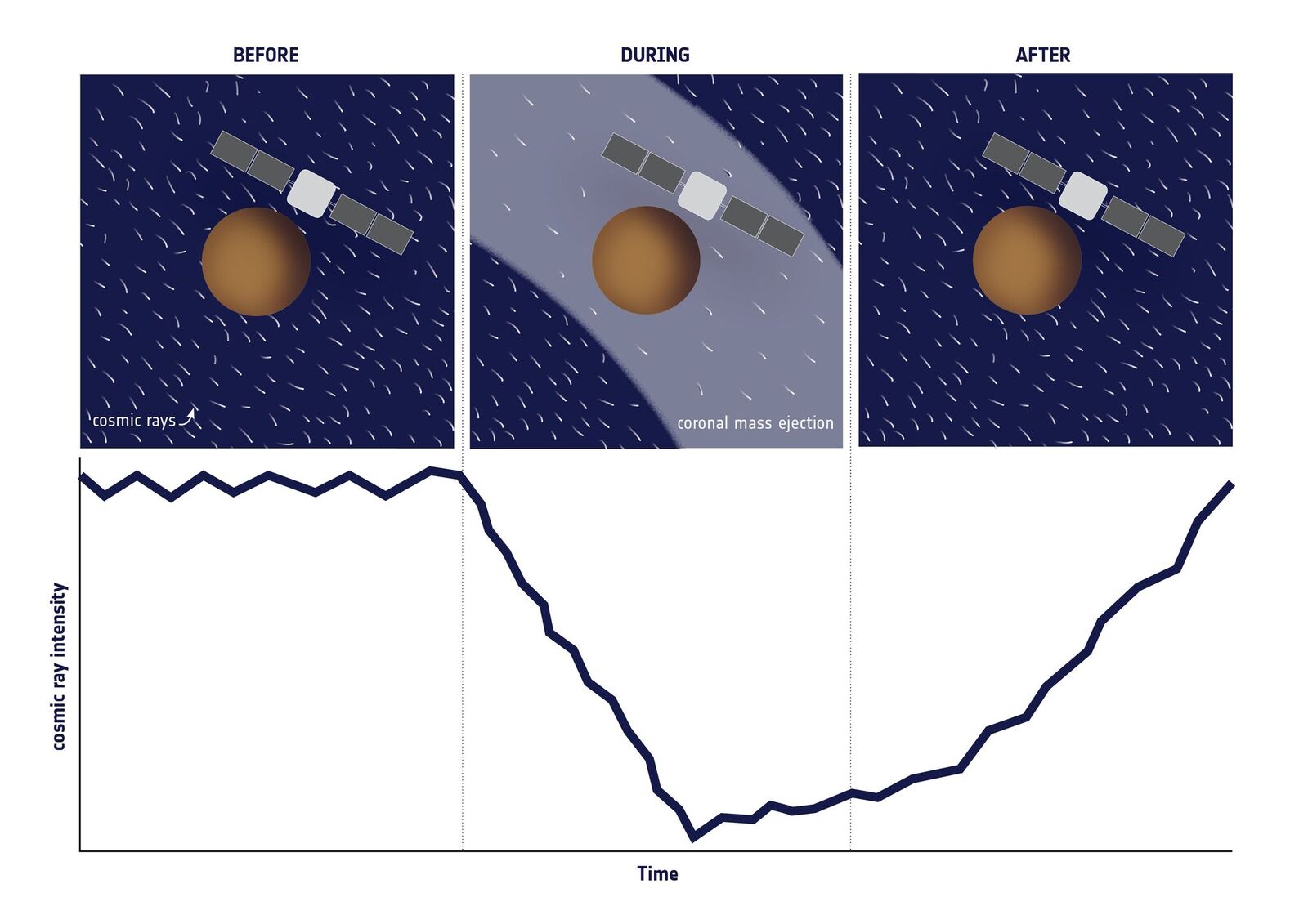 |
| Cosmic ray intensity before, during, and after the CME. |
Thanks for information from this article from AGU: http://about.agu.org/our-history/; this article from AGU: http://news.agu.org/press-release/american-geophysical-union-experts-available-to-comment-on-science-of-drought/; this article from AGU: http://news.agu.org/press-release/tracking-a-solar-eruption-through-the-solar-system/; and the above link.


Click Here: DAILY GOAL SOFTWARE
No comments:
Post a Comment